


Look-see.
A simple term for the simplest, and most often gathered, type of bird data.
You look.
You see.
You write the figure in the notebook.
It is a snapshot. No more, no less.
You have to try to use look-see as much as possible in citizen science. Even something as 'difficult' as estuary counting comes down to look-see. Why organisers ask for coordinated counts. If you all look-see at the same time, you eliminate most duplication.
As birders, we tend to get tied up and paranoid over look-see, especially when that is often what we use to record our own story. It might be a long-exposure- you might sit in a hide for an hour and take your look-see at best point during that hour. You may have crafted the shot. Taken it when you thought the number highest. But still just one shot.
Some observers make movies. Movies tell a story so much better. The approach is the same for whatever species you are interested in, be that a woodland winter feeding finch flock, a late summer dispersal of Starlings or an estuarine roosting shorebird. You have to capture the whole story.
That capture is often by a trademarked technique called "Through-the-tidal-cycle counts". Think of it like a slo-mo. You take a shot, wait 30, 60 mins, take another snapshot, wait similar, repeat, wait repeat, right through the ups and downs of a tide.
I make a lot of t-t-t-c shorts. For many years I concentrated on the three, four hours around the mudflat covering, taking shots for many angles of the southern shoreline, to piece together a drama-documentary.
Of course, everyone's a critic. And often they don't appreciate the techniques being used.
Yesterday, I had some rushes reviewed. Someone had clearly seen my 1,200 Avocet count at the start of the year.

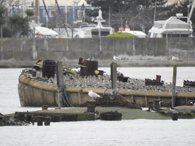
During my decade back birding on the Medway, there have routinely been surges helping to drop flotsam on the highest tidelines. Where I found my deadeye. The nautical name for those circular wooden blocks you see in rigging, blocks with a groove round the circumference to take the rope. I like to think it came from the hulk of an old Thames barge.


 |
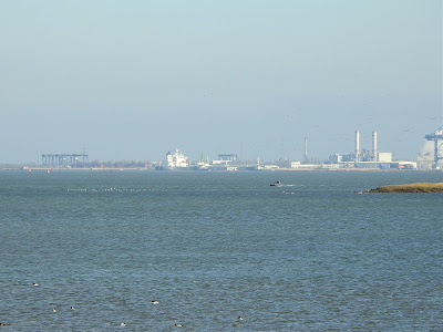
| Greenborough, with Burntwick beyond. (Yellow circles where banners mark position of Sandwich Tern colony. Not long to go..) |

During my decade back birding on the Medway, I've got to know just how much effect surges can have on the cover timings. Daily surges can often be minimal, adjusting my start times by matters of minutes, but sometimes the covering time has moved by up to forty, fifty minutes.
You learn to respect the surge. It can change the high water time as well. The surge can run faster than the tide, and when this happens, the difference in height is recorded in the records by the official name of 'residual'.
Today's forecast wouldn't actually create a residual, but it would help extend the time period of the top of the tide. The wildfowl and waders would have to ride out the highest waters for longer than normal. Just another fifteen, twenty minutes, but an energetic cost, especially for the waders if they found themselves having to aerial roost.
----
Tuesday.
Bench junction. The north-east corner of Eastcourt Meadows, at the north-west corner of Sharps Green Bay. Great views down Bartlett creek and out to the western basin. Normally I'd be out on Horrid Hill, but a 6.9 metre tide is one that will close the peninsula path. It will go under water. And I wanted to watch the general movements from both main bays of the Country Park- Sharps Green and Rainham.
The front came through over the high tide, and viewing conditions were lousy, but it was still possible to take in the spectacle.


A six metre high tide. We're in the springs. An old historical term that has nothing to do with the spring season we are all dreaming of right now in the mirk of winter. Spring tides refer to water "springing forth." They come like clockwork. Two sets every lunar month, when the moon is full, or new, when the moon's monthly orbit has aligned with the sun, and their gravitational forces work in unison.
The opposite is a neap tide. Olde English, nēpflōd, when the moon's monthly orbit is out of synch with the sun, and the gravitational forces are not working in unison - the tides are nipped.
A low neap here can come in around the 4.8 metre mark, a high spring, 6.2, 6.3 metres. Many of our roosts go under on springs, and birds have to change behaviours.
-----
But whilst we all learn about the tides, from schools, from documentaries, from other birders, we rarely hear of other elements that play a major part in the final height of a tidal cycle. One being the surge.
When weather is fair, air pressure is high, and pushes down on the lunar tidal bulge. Tides come in lower than forecast.
When weather is foul, air pressure is low, and allows the lunar tidal bulge to increase. Tides race in higher than forecast.
During my decade back birding on the Medway, there have routinely been surges of up to about half a metre, sometimes a metre, rarely up to a metre and a half. But surge peaks do not often align with the actual high tide, or low; the peaks usually come a little before (and can sometimes mean the highest point of a tidal cycle comes before the forecast high tide),
To work the high efficiently on the Medway, you have to study surge forecasts.
----
Monday.
Fairmile wharf isn't a site that attracts many birders. I haven't bumped into one there yet. Sure, they will visit, I might only get there a handful of times over a tidal cycle, it's just that I haven't seen one yet. There are better honeypots next door for the the general birder.
But once you appreciate you have a fair sightline to the estuary head, and a decent but distance view to the eastern boundary of the estuary at the Sheppey bridges (and you're that way inclined!), you realise a good spot to study flightlines.
Plus there's a roost on view; the old concrete barges just east of the Strand. General rule of thumb, more often used through the high tide on neaps than springs. Today proved an exception, and it was fun to watch the public stopping to enjoy the show.


> High tides: for January 1st bird races, at 10:48, so covering is around dawn for many of the south shore sites. For the drop, the hour or so after midday should see most flighting.
January '22 WeBS count is set for Sunday 23rd, towards the end of a spring cycle, so birder counts away from that date would no doubt be welcomed by Bird Track, etc. For weekend birders I'd suggest 29th-30th as worth a mid-morning visit for the least-disturbed neap tides.
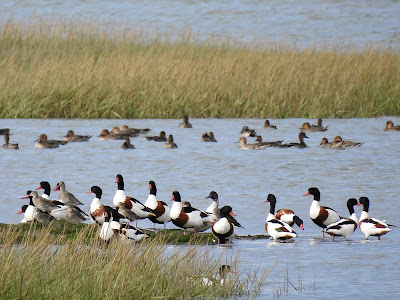
> Wildfowl: The switch from mudflat to onshore feeding will be almost complete, especially as the algal growth was in poor supply going into winter this year. Goose/grass time. Brent will be in big numbers at grassland sites such as Frog farm (see below) and Chetney.
> Nocturnal behaviours: Back to those fields. At night*. If Santa got you a thermal imager for Christmas, or even if you just have an app on a mobile, worth scanning a field. By reading through some tweets it seems some birders just beginning to appreciate distribution differences between day and night.
*Carry out your own risk assessments, natch.
> Passerines: First hints of locals reclaiming breeding territories. Why some feeding stations don't get busy for the first hour or so. If checking cover crops, you may have good numbers of winter migrants in from first light, but 'our' birds a bit later to breakfast; why Reed Bunting numbers usually better in second hour of daylight. The males start to revisit territories, offer a little song, then go feed and perhaps roost communally but more often start to sleep on territory (why ringers catch more females/ young at roosts).
> 'Seawatching': January sees the start of the best period for territory-holding divers on the estuary. The theory is that diver numbers increase in the southern North Sea as birds stage before moving north from March onwards. Certainly there are more first dates for divers from the turn of the year.
When I returned in 2013, previous quarter century had shown the just-about annual Great Northern to be most common, out-ranking Black-throateds by 6:1. Daily coverage has shown Great Northerns as annual in very small numbers. Red-throateds tend not to hold territories on the Medway so, although numbering around Great Northerns, are much harder for the occasional visitor to bump into.
> Roosts: With wader numbers at their peak, worth noting satellite roosts. These are the smaller gatherings over the top of the tide that never carry much publicity (one of the elements NE struggled to identify from WeBS, etc, when first looking into the new Coast Path route).
Satellites are often very important, as may well be the safe roosting for first winter birds (Oystercatchers a prime example) or even 'local' birds. Species such as Redshank do not form one large roost. All smaller gatherings are worth recording/reporting.
Tide sites of the month
1) A spring covering at Funton/Chetney. Always something to look at
2) A neap high tide at The Strand. Peak month for numbers at the estuary head. The remnants of Gillingham marshes can hold some nice neap roosts now.
3) An ebb watching the Deep Water Channel. Calm waters on the Cant, between Sheppey north shore and the Channel can hold a few birds and as the tide retreats, waders arrive from west and east. Notoriously underwatched, often rewarding.
My perfect January day would be..
Odd choice, this one, but I'm imagining really hard weather conditions and planning a day close to home (my perfect day after all):
- Morning: Dawn, Motney/Horrid Hill. Birds in the bushes.
- Mid-day: Riverside Country Park mound. (Walking all bits east and west, returning here for the visitor centre, cafe and loo. Got to have a bit of a warm up.)
- Late on: Bloors/Horrid, for the gulls to roost..
Top 10 tips for January:
General birding:
1) Late December as I write this, and so many 'toggers bemoaning the dreary conditions. So, when it is forecast, make the most of getting the early light behind you. Best sites? Try watching westwards from Fairmile Wharf, Bloors Wharf, Motney and Queenborough/Rushenden.
2) Some of the best late light viewing spots are also really underappreciated. Walk out from Lower Halstow to Shoregate creek on anything barring uncovered. Or try Fairmile, or the north-east corner of Eastcourt meadows, for great views out towards Nor.
3) Kit advice. Take a chair. I use three different sizes/weights; depending on how far I intend to walk/ how long I intend to stay and watch. No hides here, all seating will be cold, or damp (or both). If going where benches, the other option is a padded garden kneeler. If you feel comfortable, you'll scan for longer.

4) Study the near continent's snow cover. Three days of not getting to easy feeding means biggest numbers of wildfowl making escape flights. Good time to find an odd goose.
5) Stand back. Flight Initiation Distances will be at their shortest, as weather has greatest impact on risk/reward ratios, but you still won't be tolerated as much if you go stand right on the seawall edge, especially if alone. You are a predatory threat. Two plus birders will be like cows in a herd, just prey, until they stop and stare. Don't stalk per se, just act slow and stupid, and they'll tolerate you more.
Tips for adding value:
6) Mimic BTO WeBS Core Areas. If you can count to same boundaries, then your numbers can provide great comparisons. An interactive map of WeBS Core Areas for the whole country can be found here. This month we look at two presently uncounted sectors.

Twinney (22851) is made up by two familiar sites landward side of the seawall, Frog Farm and the Brickfields. The Frog fields are the most important part, often holding feeding Brent Geese. The reedbed in the Brickfields doesn't have enough open water to attract much, but good for a Water Rail or two, and always an enjoyable walk.
Barksore marshes (22464) are a majorly important element of the south shore. Plovers and Curlew often present in good numbers at the farmed n-ne section, the main fleet a sanctuary for wildfowl in poor weather (or when disturbed from Funton creek). The nearest pools (close to the freshwater feed of Funton creek) often hold the Greenshank roost.
The only way to view the enclosed marshes is from the viewpoint on the Saxon Shore Way due south of the old brickworks. A brilliant spot, but best not to leave vehicles unattended (walk from Lower Halstow).
Strangely, this WeBS core sector still includes the south-western dogleg element of Stangate creek (the saltings viewable from Chetney) and the vast majority of Halstow creek (viewed easily from the Brickfields). Historical leftover from when birders last walked the area to count, decades ago? Whatever the reason, any supplemental counts of any part of 22464 would be of great value.
BTO WeBS Alerts are issued for those species for which a site was nationally/internationally important at the time it became protected (the 'designated features'). Of our 15 designated SSSI features here, as at end 2021 10 had High Alerts issued, 2 Medium Alerts. All counts for any of these species can prove useful data. Check their excellent interactive webpage out for full details, species accounts and graphs.
7) Make your Shelduck count:
SSSI: High alert (for long term trend)
Short-term (5 years) +33% / Medium term (10 years) +35% / Long term (25 years) -51%
Better coverage in the past decade is perhaps behind the short/medium term improvements. Annual peak WeBS nos are found in December, which ties in fairly well to a national WeBS peak in January; many birds make their way back into the UK from their Waddenzee moult sites through the south-east then filter on towards their breeding grounds. Bearing in mind there is turnover through the south-east right now, it could be the once-a-month WeBS snapshot will not pick up the peak- any counts at this time of year would be welcomed.
8) Make your Shoveler count:
SSSI: Medium alert (for medium term trend)
Short-term (5 years) +4% / Medium term (10 years) -29% / Long term (25 years) +24%
Nationally important counts are anything over 190 and Shoveler wobbles around this level. With WeBS counts being uncoordinated, it is possible to miss significant numbers (the birds that loaf at Bloors may hide up on Rainham saltings, or may switch to Nor, where potentially missed by the boat counters. Birds Funton creek/Bedlams often flip over the walls to Barksore (uncounted)/ Chetney.
Just two examples where simply taking monthly peaks from each of these areas make for overcounts, but where if a very low WeBS count for the interconnected sites extremely low, probably worth using the largest supplemental count for the sector. Why all counts welcomed, but where sectors appreciated (not, say, just counted as 'Riverside Country Park').
9) Count a 'non-bird': Red-breasted Merganser (SPA):
'Non-featured species' on WeBS Alerts are those for which we do not hold internationally/ nationally important numbers, but for which trends can still be monitored and black= bad - in this case, black over all three terms:
Short-term (5 years) -77% / Medium term (10 years) -79% / Long term (25 years) -96%
The biggest problem here is the birds favour creeks out and around the islands, but don't like the counters' rib that much. When birds are disturbed, they will turn up closer to shore, but with shore/boat counts being uncoordinated, easy to miss.
In the mid-nineties we had counts of 20s, 30s, 40s. We have nowhere near that number now, but double figures are routine, whereas two of the last five WeBS seasons returned zeros (the three other winters showing just 2, 2 and 6). Why all supplemental counts could be of great use.

10) And this month's whacky suggestion is:
Make a deliberate point of dropping in to the Riverside Country Park visitor centre to say 'hi'.
There is a legal definition of a Country Park, essentially to provide for recreational activity in a countryside setting. This means they are not necessarily a nature reserve, although they are often found within/alongside legally designated sites.
The site has to provide for all user groups, but the current Ranger team (with full support of their employers, Medway Norse Ltd) are keen to understand/improve the countryside element through more environmental monitoring within the Park boundaries and are there is also a desire to achieve Local Nature Reserve status for Riverside.
Back in October I was lucky enough to be invited to give the team a talk on the birds of the Medway, and how they can help visiting birders to get the best experiences. The team have now started looking at their own specific avian monitoring schemes to supplement to existing national surveys and, using the knowledge of their lifelong birder in the ranks, develop team identification skills. The team really should be applauded for self-starting these efforts.
And they're looking to provide a better experience within the Visitor Centre for all levels of birdwatcher. Early days, but there is now a birdwatching information board in the main window, with all the usual, the tide times, Bird Wise Codes of Conduct, etc. plus info they feel covers the questions they get from visiting birdwatchers of all abilities. They have a map up of Park boundaries as well as we birders are prone to extending the boundaries of the RCP (latest example I've seen had a site said to be RCP some 2km further on along the seawall).

(P.S. And if you do ever find anything good, please do follow the Birdwatchers' Code of Conduct and let them know; some staff are only just setting out on their birding adventures and you providing them with exact location, etc., even a little on the species' jizz/status, will help them provide a better experience for any twitching the bird who call in expecting detailed directions.)
Hot off the press for January 2022:
Avian flu is a concern in the UK this winter, and up-to-date control zones can be found via an interactive map here. A sniff of a concern here in the Christmas period have been reports from local bait diggers of a trio of Little Egret tideline corpses. For whatever their reasons, the corpses were taken ("I've kept the legs at home"), so I'm now keeping the DEFRA hotline for reporting corpses in my notebook to pass on to any of the public who mention seeing one: 03459 33 55 77. (Full public advice regarding wild birds here).
For those who keep score, this month's potential:
(Since moving back in 2013, checks at the end of each year have shown annual totals in the 180s, 190s. That's helped by my birding daily here, but a north Kent 200 should be on for someone willing to chase it. This might help incentivise.)
January? 90 species for the month should be an achievable target.
If you, like me, would sneakily include the Medway Deep Water Channel extension out past Sheerness, a watch off of Grain or Sheerness/ Minster will have you over 100.
And finally, something for the listers: what's Medway missing?
This month's top three dreams/nightmares:
1) Okay. I wrote about Black-throated Divers earlier, so I'm playing word/bird association - Black-throated Thrush. So few decent passerines get seen here, yet we still have potential. The apple orchards are full of windfall and fruit left on the branch. January is always a big month for orchard feeding. Yet on my transits since 2013, I've seen as many birders on the orchard footpaths as I've seen Black-throated thrushes..
2) Alright, let's choose a 'proper' marsh bird, and going for this simply because of goose/ green mentioned earlier - Lesser white-fronted Goose. Daft considering how few White-fronts we get? Well, bear in mind the east Sheppey birds can and do turn up at Elmley, from where a short flight to the Medway. White-fronts here often go under-reported because they get flushed from their favourite feeding areas on the game farms/ shoots, and there is a lack of birders out looking. Chances are you'll get to be White-front King '21-'22 if you do try.
3) One for the garden watchers as the RSPB Big Garden Birdwatch is coming (29th- 31st). Continental Great Tit. 'Only a race' do I hear? 'You won't get it past the county rares, these things are clinal'. Okay, a gap we might never fill on the Medway list. But the fun here is to help look hard at the feeders. I picked up on a good candidate one January, when living just outside Rye. I would have 'ticked' it, but had made the mistake of putting up a shedload of nestboxes on the surrounding farmland and the dang thing went and bred in one. Paler birds can and do occur in our own population in the south-east. So, if you do turn one up, get a photo for the County Recorder but also smash all nest-boxes within a half-mile radius so it has to bugger off come spring and you might, just might, get a glimmer of a hope of a chance of acceptance.
All three suggestions just a bit of fun; if you do turn something up, well done; if not, you'll have had a hoot trying.
That's it for January. Time to get out there and look...

My garden is rubbish. It's a yard. It did attract birds once, when there were orchards over the road, but th ey're a building site at the moment. In some 38 years of calling it my backyard, 2021 is the first year I've not seen a Blue Tit land in it.
Landing is key for RSPB's big garden birdwatch. 2 rules. (1) Count is exactly an hour. (2) Count everything that lands. RSPB gurus will do the rest, adjust your species tallies based on how many times the same Blue Tit visits the same garden in a 60 minute period and work out the national result.
Over the pond? They don't want you counting the same bird twice. So, you record the maximum present at any one time. And you can sit watching as long as you like. You just have to record exactly how long and tell them that as well.
45 minutes gone and nothing but Sparrows. Peak 12. Landed 43. I might just close my eyes for five minutes, then do a final 15. No harm in that.
Just five minutes. Just fi.. zzzzzzzzzzzzzz
Nooooo! We really can't do circles. Nooooo! The Hoo crew would hate it. They'd want the whole peninsula in, so would centre it on Northward Hill. That way they'd get the off-Peninsula bits of the Medway towns they've always claimed because someone once lived close-by, but not quite on, the geographic peninsula.
Nooooo! They'd get parts of Essex as well, but they've never really bothered chatting much with them. Okay, there was a collaborator once at Cliffe who swapped messages with East Tilbury, but they put a stop to that. (I wonder if they've ever realised the real reasons behind Essex surveyors working parts of Hoo in recent years, finding all the goodies. Come the revolution..
Ohh, and what if the South Swale gang wanted all their patches in their circle? If they based it on Oare, they'd have all the juiciest bits of Sheppey too. They wouldn't want Sheerness, no birds there. They could leave it out. Heck all that'd be left of my Medway circle would become the perineum, separating the..
Wake up Kev(!) You're having a nightmare(!)
Phew, just a dream. Of course. All silly stuff. That'd never happen in America, would it?

 |
| "Mmmmmmmmm Sausage Roller" |