Thursday 20 January 2022

Moving pictures

 Look-see.

A simple term for the simplest, and most often gathered, type of bird data.

You look.
You see.
You write the figure in the notebook.

It is a snapshot. No more, no less.

You have to try to use look-see as much as possible in citizen science. Even something as 'difficult' as estuary counting comes down to look-see. Why organisers ask for coordinated counts. If you all look-see at the same time, you eliminate most duplication.

As birders, we tend to get tied up and paranoid over look-see, especially when that is often what we use to record our own story. It might be a long-exposure- you might sit in a hide for an hour and take your look-see at best point during that hour. You may have crafted the shot. Taken it when you thought the number highest. But still just one shot.

Some observers make movies. Movies tell a story so much better. The approach is the same for whatever species you are interested in, be that a woodland winter feeding finch flock, a late summer dispersal of Starlings or an estuarine roosting shorebird. You have to capture the whole story.

That capture is often by a trademarked technique called "Through-the-tidal-cycle counts". Think of it like a slo-mo. You take a shot, wait 30, 60 mins, take another snapshot, wait similar, repeat, wait repeat, right through the ups and downs of a tide.

I make a lot of t-t-t-c shorts. For many years I concentrated on the three, four hours around the mudflat covering, taking shots for many angles of the southern shoreline, to piece together a drama-documentary.

Of course, everyone's a critic. And often they don't appreciate the techniques being used.

Yesterday, I had some rushes reviewed. Someone had clearly seen my 1,200 Avocet count at the start of the year.


"So, you counted them yet today? How many are there right now?" Clearly trying to see if we were both focused. I also checked my filters.

"Well, when I counted them an hour ago, there were a hundred and eighty. Half-hour later another eighty flew in, but I haven't counted 'em since. Would you like me to take a rush shot now?"

The second unit director paused to consider the offer. I called 'action'. The chase scene had started, stage right. Two hovercraft were buzzing the Motney Hill RSPB reserve a kilometre distant, where, out of view, I knew there were an army of extras.


Avocet numbers shot up. I'd only got halfway through getting my count proof and decided to abandon it to explain the relevance of the ongoing chase to the story. "There are usually three roosts that can come together here; this, close-up, Bloors (not their favourite), just offscreen there's Motney and a neap tide roost/ pre-assembly roost in Otterham. They might, might all come together asthe covering tide rises. Think of this as a daily four hour epic.

Industry techniques were lost on him. Only interested in unfocused close-ups (a no 'scoper), he switched off, packed up and moved away, muttering something about 'clearly special effects, clearly using Supermarionation, you can see the strings'.

Everyone's a critic. Don't believe such hype, go see things for yourself; snapshots only ever tell a part of a story.

Here, try to say the whole thing is captured in the one snapshot you've seen and you could get a free presentation of the Director's Cut, with commentary. Comes with a warning: any attempted screenings will only end when we reach the note in the script margin 'Exit, stage left, pursued by a bore.'

------

This blogpost, although based on true events, is a work of fiction. Any similarity to birders living or dead is purely coincidental. No birds were look-see counted during the making of this blogpost. Dedicated to all other members of the t-t-t-c Guild out there.

Thursday 6 January 2022

Surge Wars, episode #6: Return of the deadeye

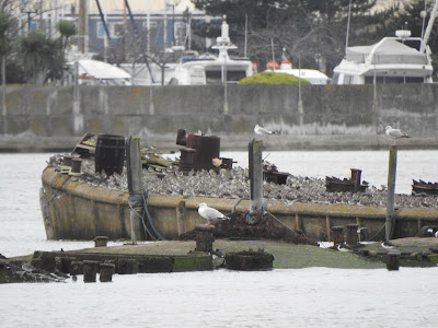
During my decade back birding on the Medway, there have routinely been surges helping to drop flotsam on the highest tidelines. Where I found my deadeye. The nautical name for those circular wooden blocks you see in rigging, blocks with a groove round the circumference to take the rope. I like to think it came from the hulk of an old Thames barge.


Of course, at some point Deadeye earned a second, more well-known meaning: an expert marksman.
----


Wednesday.

Deadeye birding from Tiptree hill.


From the WeBS counter handbook: "The route should be designed to ensure that the whole count area is viewed (the reliable range of most binoculars is around 500 m, especially if species are in mixed flocks; with a telescope, if topography and weather conditions allow, experienced observers can identify birds up to three or four km away).."

500 metres with binoculars? That's Deadeye. Sure, nice if you can get closer than that, and have enjoyable views of your birds, but that's general birding. WeBS is a job, getting that estuary total calculated to the most accurate number. You're in the Marines now soldier, and if you're the best, then you shouldn't be on the easy stretch, you're needed on the toughest.

Agent Leroy Jethro Gibbs uses a M40A1 sniper rifle, which has an effective firing range of 800 metres. If that terrorist even squints to break wind, Agent Gibbs will have him.

Pfft. Agent DunnoKev uses a Swaro' x30-70. He can pick off a Dunlin at a four kilometre distance.


Of course I can't(!) Both those characters are fictional. That four 4km distance isn't for individual birds. But you can pick up flocks. Sure, you won't see the Baikal in the Teal, but that Baikal isn't the point of WeBS. You need your best troops picking up on the jizz, getting down and dirty and hunting out the flocks the grunts won't get.

Tiptree.

Overlooks Barksore. Flocks readily identifiable, can be counted. Many individuals can be picked out.
Overlooks Millfordhope and Greenborough. Flocks readily identifiable, can be estimated.
Overlooks Burntwick. Out of range for flocks through x20s, x30s. But with a sniper's 'scope?

----

Yesterday it was clear that some birds were moving from the eastern basin over the high tide, to join western birds around the Hoo area. Steady pulses of braces, tens, twenties coming in from the west.

Today, in good light, possible to pick up the big flocks out over Greenborough and Burntwick, and simple answer to how many move- not many as a percentage of the birds hanging on there. The old inner seawalls might have been under water, but in places, just under water and lines of waders played tippie-toes over the submerged ground. Constant motion. Birds that could no longer hold on had to move and try to fit on at the next; often, both sets of birds up. But few flocks willing to make a longer flight, either to the north shore or to the western basin. A scan showed 'islands' left, and a fair sized chunk of Burntwick as well, but unappealing. As land above the surge zone, often matted. clumped grassland simply not suitable for roosting waders.

So, hold on. Squeeze in if you can, or aerial roost. And wait for the turn.

Wildfowl? Normal tactic of swimming over/ alongside the flooded islands; less wave action, drift, some additional feeding on out-of-reach plants/seed. Again, numbers are brought together by the conditions, and some flight a distance, but most hold on. Today, many dabblers were already on land at quieter sites. Sadly, not many of these. Barksore can hold good numbers, but empty, as was a large amount of Chetney. Working areas. No reserves. Birds get moved around. Luck of the draw.

On the top of the tide, an observer at Shoregate has closer views of the rafting birds and the flock flights. Similarly, the count team on Chetney have good views out over Stangate. But Tiptree, literally, has the overview.

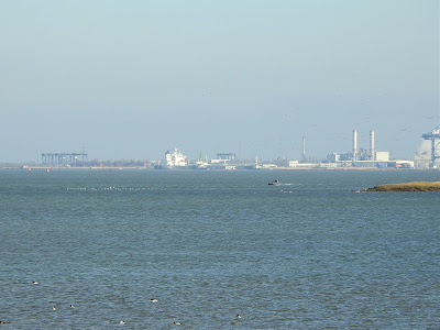
Greenborough, with Burntwick beyond.
(Yellow circles where banners mark position of Sandwich Tern colony.
Not long to go..)

----


That viewpoint (circled in red, above) has been known for decades - this map a couple of decades old from "Where to watch birds in Kent, Sussex and Surrey", Taylor, Wheatley, James, 4th ed., 2003. (That 'P' should now carry a warning- cars do get broken in to there- safer to park in Lower Halstow and take Saxon Shore Way (new Coast Path will make this walk safer by removing the road stretches- not long now!).

Known for decades that Tiptree gives great (but, yes, distant) views of one of the best spectacles the Medway can provide. Very, very few birders bother. Why? We like honeypots, we like close ups, very few want to count. It should be like a Mecca though; every birder should have to do it once. And soon, as the field is under threat of becoming part of a large solar farm.

And how many more years can the waders hang on? If the shore was safer, those flocks might head for them. They're not. Whether they will be able to provide rest when the islands go, not sure. Plenty of work to be done.

----

From Tiptree, you can also see where The Lappel was. It's under part of Sheerness docks, right under those wind turbines in the photo above. When I started birding it was mudflats.

There are existing legal requirement to not allow SPAs to deteriorate further. Could an island be saved? We have one reserve out there (Nor), where work could be done. Expensive, but if we had a Lappel Bank situation now (part of the estuary built on at Sheerness where developers found to be guilty of not mitigating for losses) the argument for compensation to stay within this SPA is strong. The Lappel mitigation went to Essex.

'British Birds', Sept 2015, has an interesting opinion piece on the Nature Directives and highlights Lappell (sic). The authors, Farrar and Costello, say Wallasea island a great example of the restorative approach, but at the time the RSPB, in advising on best site, could not see anywhere on the Medway, even their own island reserve Nor marsh, would providing as much value. One can only hope now that the authors and RSPB would agree reparative work needed on this SPA.

"The evidence is unecquivocal: the EU's Nature Directives are effective when implemented properly."

Each SPA has to be defended. The RSPB's involvement with the reprofiling of Hoo island could have led to more, perhaps even a reserve, but didn't (who wants an island previously used as a tip by a Naval Dockyard?). And present plans for schedule one breeders Sandwich Terns include providing (and hoping they'll find and use) to habitat elsewhere on the greater Thames. And hoping birds will switch to land roosts onshore where primary use farmland.

You knew it was coming- yes part of that Lappel assessment would of course have been based on available data. Sadly, we know that was flawed data.

Now you know why I went with 'wars' in the title for this trilogy. It's an uphill battle, but there is still time to win some of the small but significant battles here on the Medway, even if we seem doomed to eventually lose the war.

Plenty of loose ends for the next trilogy.

Surge Wars, episode #5: The haywire strikes back

During my decade back birding on the Medway, I've got to know just how much effect surges can have on the cover timings. Daily surges can often be minimal, adjusting my start times by matters of minutes, but sometimes the covering time has moved by up to forty, fifty minutes.

You learn to respect the surge. It can change the high water time as well. The surge can run faster than the tide, and when this happens, the difference in height is recorded in the records by the official name of 'residual'.

Today's forecast wouldn't actually create a residual, but it would help extend the time period of the top of the tide. The wildfowl and waders would have to ride out the highest waters for longer than normal. Just another fifteen, twenty minutes, but an energetic cost, especially for the waders if they found themselves having to aerial roost.

----

Tuesday.

Bench junction. The north-east corner of Eastcourt Meadows, at the north-west corner of Sharps Green Bay. Great views down Bartlett creek and out to the western basin. Normally I'd be out on Horrid Hill, but a 6.9 metre tide is one that will close the peninsula path. It will go under water. And I wanted to watch the general movements from both main bays of the Country Park- Sharps Green and Rainham.

The front came through over the high tide, and viewing conditions were lousy, but it was still possible to take in the spectacle.


----

Things might seem chaotic at first, so many birds adjusting, so many small flocks lifting and landing, lifting and landing, but there was a movement from the southern shore out to Nor and Friars. This is normal as the tide progresses, but today it was almost masked by individual hesitancies. Normally, movement in sizeable flocks. Today, handfuls at a time, both wildfowl and waders. Down, presumably, to the grim conditions during the passing of the front.


They got there in the end. Many of the wildfowl remained within the old breached walls of Nor. The northern seawall, somewhat higher, together with the submerged reefs of walls to the south, provide shelter, almost an atoll effect, much easier to ride the shallower waves.


The waders, finding the southern walls going under, with Friars saltings a little after, had to make for another roost. This proved to be their usual choice off Hoo island.

There are patterns in the chaos.


By the top of the tide, the path around Eastcourt Meadow was breached in three places, Sharps Green car park was semi-submerged and the causeway that forms Horrid Hill peninsula was under.


The new normal. The Environment Agency already has plans in place to raise the seawall the length of the Park. Sure, we'll see a lot of seawall scrub habitat lost in places, but vital to protect lives. Fun talking with the few public trying to make their way along the seawall. "Never seen it so high!" usual exclamation. cheekily sneak in a bit about climate change and rising waters and faces go blank, interest lost. We don't cope well with things going haywire. Just ignore it and it might go away. 

Don't look up. Them waders can just sky-roost.

Surge Wars, episode #4: A nipped hope

 A six metre high tide. We're in the springs. An old historical term that has nothing to do with the spring season we are all dreaming of right now in the mirk of winter. Spring tides refer to water "springing forth." They come like clockwork. Two sets every lunar month, when the moon is full, or new, when the moon's monthly orbit has aligned with the sun, and their gravitational forces work in unison.

The opposite is a neap tide. Olde English, nēpflōd, when the moon's monthly orbit is out of synch with the sun, and the gravitational forces are not working in unison - the tides are nipped.

A low neap here can come in around the 4.8 metre mark, a high spring, 6.2, 6.3 metres. Many of our roosts go under on springs, and birds have to change behaviours.

-----

But whilst we all learn about the tides, from schools, from documentaries, from other birders, we rarely hear of other elements that play a major part in the final height of a tidal cycle. One being the surge.

When weather is fair, air pressure is high, and pushes down on the lunar tidal bulge. Tides come in lower than forecast.

When weather is foul, air pressure is low, and allows the lunar tidal bulge to increase. Tides race in higher than forecast.

During my decade back birding on the Medway, there have routinely been surges of up to about half a metre, sometimes a metre, rarely up to a metre and a half. But surge peaks do not often align with the actual high tide, or low; the peaks usually come a little before (and can sometimes mean the highest point of a tidal cycle comes before the forecast high tide),

To work the high efficiently on the Medway, you have to study surge forecasts.

----

Monday.

Fairmile wharf isn't a site that attracts many birders. I haven't bumped into one there yet. Sure, they will visit, I might only get there a handful of times over a tidal cycle, it's just that I haven't seen one yet. There are better honeypots next door for the the general birder.

But once you appreciate you have a fair sightline to the estuary head, and a decent but distance view to the eastern boundary of the estuary at the Sheppey bridges (and you're that way inclined!), you realise a good spot to study flightlines.

Plus there's a roost on view; the old concrete barges just east of the Strand. General rule of thumb, more often used through the high tide on neaps than springs. Today proved an exception, and it was fun to watch the public stopping to enjoy the show.


----

Me? All about those flightlines. On a spring they usually depart north-east. Not today, the majority stayed. Those that did move went more east- south-east. Why?


The roosts to the east, on Nor and Friars, and in Sharps Green Bay on the wrecks, usually have room for latecomers. And often stay, in small part, available. January, wader numbers peak and surges put some sites under water. A combination the day before of not much room at the inn, and not many desirable locations. Then the birds make for Hoo, and to a lesser extent, Darnet.

Both were busy. Why risk/reward prompts individuals to stay longer at a site close to what can be a busy marina/shoreline. Even when a potential 'threat' (a crow) landed, instead of moving off they held on, at a distance.


Individuals making assessments. Part of their choice is based on the assessments of others around them, but there is no real flock mentality. They are making the best of what is available, and their choices are limited by the surge.

There is also chance. The wind is strong, from the north-west, and why waste energy fighting it when there is a chance of some room along the way? They can see congeners up, wing flashing at distance. Try their luck, hope for the best.

Wrecks like these are important. Hoo island was reprofiled and raised up a few years back and should see out the other islands as they fall to sea rise, but right now isn't wet enough to appeal greatly. At a glance, a sea of pampas. There are some pools, but the important bit for now is jost off the island itself, in the north-east corner; saltings surrounded by wrecks.

The birds that had chosen the Strand's line of concrete barges saw out the top of the tide. Win. Every surge a battle to be won. And the battles are coming more frequently.